Graphic Plots
On July 30, 1920, Marie Tharp was born in Ypsilanti, Michigan. A pioneering oceanographic cartographer, she mapped the ocean floor and co-discovered the Mid-Oceanic Ridges, along with her colleague Bruce Heezen, Columbia University’s team leader of ocean ridge mapping.
As they worked down the North Atlantic and Tharpe’s meticulous plotting revealed more and more of the huge ridge on the ocean floor, she was first to think it might be a rift valley, where continental/plate separation occurred, creating the submarine heights on either side of the rift. Tharp plotted with pen and ink from thousands of sonar readings, drawing topographic maps from Heezen’s data along with data collected from the Woods Hole Oceanographic Institution’s research ship, Atlantis, and seismographic data from undersea earthquakes.
Heezen and Tharp published their first physiographic map of the North Atlantic and its Mid-Atlantic ridging in 1957.
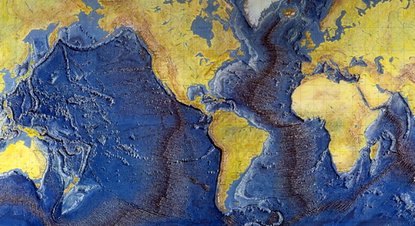
Over many years, her painstaking work revealed an active cleft and approximately 80,000 km (50,000 mi) of marine ridging that circle the planet.
Collaborating with the Austrian landscape painter Heinrich Berann, the famous Heezen-Tharp physiographic map of the entire ocean floor made its debut in 1977. When satellites were finally capable of “seeing” down to the ocean floors, their computerized images proved Tharp’s maps to be accurate. Tharp’s observations supported theories of plate tectonics and helped us understand better how the Earth works. Her work continues to provide insight for research and education in oceanographic study.
The yearly Marie Tharp Fellowships in the Earth, Environmental, and Ocean Sciences are awarded in her name at The Earth Institute at Columbia Climate School.
B Bondar / Real World Content Advantage