Extreme Clicking
On February 21, 1849, Canadian inventor and surveyor, Édouard Gaston Daniel Deville was born in France. A naval school graduate who served in the French navy, he conducted marine surveys around Peru and South Pacific islands, using sounding lines, to measure and describe features of importance to maritime navigation.
After retirement, Deville immigrated to Canada where he jumped into his former trade as a surveyor, to become, within a few years, the Surveyor-General of Canada. One of the first things he did was to introduce the use of iron survey posts to stop the practice of using wood as survey ground pegs on the prairies!
Deville’s great challenge lay in the mountain ranges ahead. The topography of Canada’s Rockies was no South Seas sail. The mountains were high, they seemed endless in number, they held glaciers as far as the eye could see, and their winter snows were invariably deep and drifting.
A former French army colleague, Aimé Laussedat who used camera views to prepare topographic maps, had introduced Deville to the principles of early experimental photographic mapping. Deville studied the relationship between geometry and photography. He then modified a lightweight but rugged camera that surveyors could carry and use with as few adjustments as possible under as many field conditions as possible. The field men took photographs and returned them with the photo data to process their calculations back in survey offices. Deville’s innovations speeded the mapping process, cost less, and were more accurate than conventional surveying technique.
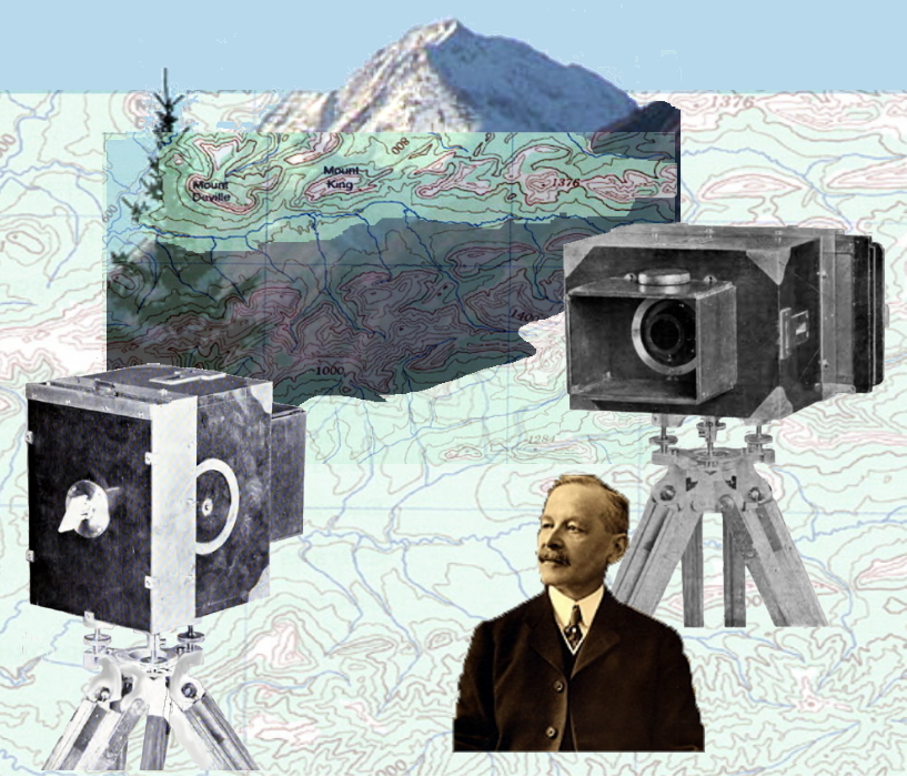
As he refined his method, the photo-topograhic technique, and photo-mapping, Deville wrote articles and pamphlets for his surveyors and a limited edition text, Photographic Surveying. He was invited to present this method of practical photogrammetry or photo-topography at the Chicago World Fair of 1893.
Deville’s innovations and information sharing transformed survey practices the world over. They provided the foundation for future Earth surveys by air and by satellite and right into the current development of photogrammetry software.
He was a founding Fellow of the Royal Society of Canada. His name is memorialized in Mount Deville, a 2924 m (9594 ft) peak in the Van Horne Range, in Yoho National Park. At the park’s entrance, near Field, BC, is an Historic Site Monument in his memory.
B Bondar / Real World Content Advantage